
MAP OF VASTERNORRLAND
(MAP CREDIT: GEOATLAS.COM)
Vasternorrland County (Vasternorrlands lan) is a county (lan) in the north of Sweden on the Gulf of Bothnia. The name Vasternorrland means “Western Norland,” as it was in the western part of the original Norrland (northern Sweden and northern Finland).
Vasternorrland’s area takes in most of the two traditional provinces of Medelpad and Angermanland. Vasternorrland has an area of 23,107 square meters (8,922 square miles).
Norrland has high mountains, rushing rivers, small cold mountain brooks, lakes, sea, forests and wilderness. Along the coast of the northern part of Sweden are many beautiful cities and towns. Some of the cities along the coastline are Ornskoldsvik, Harnosand and Sundsvall, which are major shipping centers for timber and pulp.
Skuleskogen National Park is located 27 km (17 miles) south of Ornskoldsvik and 40 km (25 miles) north of Kramfors. It covers a surface of 3,062 hectares (7,570 acres), of which 282 hectares (700 acres) are maritime. There are many rocky peaks. The highest peak is Slattdalsberget, which is 280 meters (920 feet) high.
Vasternorrland is said to be the land of Sweden’s “green gold” due to huge forests, forestry industries and a centuries-old tradition and expertise in wood-working skills.
The municipalities within Vasternorrland are Harmosand (population 25,269) Kramfors (18,681), Solleftea (19,846), Sundsvall (98,325), Timra (17,992), Ange (9,495) and Ornskoldsvik (55,964). The total population of Vasternorrland County is 245,572.
(Source: Statistiska Centralbyran, Sverige.)
The largest populations within Vasternorrland County are Sundsvall (including Johannedal, Sundsbruk and Tunadal — 58,065), Ornskoldsvik (including Gimat, Overhornas, Arnasvall and Vasterhus — 32,700), Harnosand (18,600), Timra (10,497), Solleftea (including Sollefea norra — 8,885), Kvissleby (including Njurundabommen, Skottsund, Dingersjo, Essvik and Juniskar — 8,797), Kramfors (including Frano — 6,752), and Vi (Alvik including Gustavsberg — 5,827).
HARNOSAND, SWEDEN
Harnosand the seat of Harnosand Municipality. Harnosand is a beautiful small town near the island of Harnon. It is called “the gate to the High Coast” and “the Athens of Northern Sweden.” The town has the largest open-air museum in the northern part of Sweden. The museum is called “Murberget.” Harnosand has a long and rich maritime history. Harnosand was formerly a shipbuilding town. It is located on a beautiful and dramatic coastline. There are three marinas in central Harnosand. The Adalen 3 is a tourist boat that leaves from the dock at the wharf in central Harnosand. Harnosand opened its first theater in the early 1840s. Today’s theater building is located on Central Park and was opened in 1970. The town installed electric street lighting in 1885 — the first place in Europe with such lighting. The city was first built in 1585.
The High Coast Bridge (Hoga Kusten Bron) spans the Angerman River near Veda on the border between Harnosand and Kramfors. It is the fourth longest suspension bridge in Europe and the third longest suspension bridge in Scandinavia (after the Great Belt Fixed Link in Denmark and the Hardanger Bridge in Norway). The bridge was constructed between 1993 and 1997 and was officially opened on Dec. 1, 1997. The total length is 1,867 meters (6,125 feet), the span is 1,210 meters (3,970 feet) and the column pillars are 180 meters (591 feet) tall. The maximum height for ships is 40 meters (131 feet).
Harnosand was granted its town charter in 1585. It is the county’s oldest city.
VIDEO (1:09) OF HARNOSAND # 1 — NARRATION IN SWEDISH
(VIDEO CREDIT: HARNOSAND KOMMUN)
VIDEO (5:35) OF HARNOSAND # 2 — NARRATION IN SWEDISH
(VIDEO CREDIT: HARNOSAND KOMMUN)
VIDEO (5:36) OF HARNOSAND # 3 — NARRATION IN SWEDISH
(VIDEO CREDIT: HARNOSAND KOMMUN)
KRAMFORS, SWEDEN
Kramfors is the seat of Kramfors Municipality. The High Coast Bridge (Hoga Kusten Bron) crosses the Angerman River (Angermanalven River) near Kramfors. The suspension bridge spans 180 meters and is only 70 meters shorter than the Golden Gate Bridge in San Francisco. The larger communities of Umea and Sundsvall are situated within a commuting distance of Kramfors. (Umea is the capital of Vasterbotten County — Vasterbottens lan).
VIDEO (3:34): AERIAL TOUR OF KRAMFORS
(VIDEO CREDIT: GUSTAV LORENTZEN)
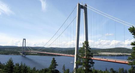
THE HIGH COAST BRIDGE (HOGA KUSTEN BRON) AT KRAMFORS, SWEDEN
(PHOTO CREDIT: UNKNOWN)
SOLLEFTEA, SWEDEN
Solleftea is the seat of Solleftea Municipality. It is located at the lowest rapids of the Angerman River (Angermanalven). The Angerman River winds through the municipality on its way to the sea. The river is 450 km and is the longest navigable river in Sweden. A building called the “Pharmacy Building” was constructed in 1889 in the neo-Gothic style. The building now serves as a library and the city’s museum. A wooden structure, the Hotel Appelbergs, is located in central Solleftea. It was built in 1882 by lumberman and innkeeper Erik Appelberg. Guests at the hotel have included King Oscar II and King Gustav V.
Although Solleftea is an age-old trading and commercial center, it was not granted its charter as a town until 1917. The town is well-known for its military regiment.
There is salmon and sea trout fishing in the Angerman River in the middle of the town of Solleftea and grayling fishing in the Meaforsen rapids of the Fax River.

MAP OF SOLLEFTEA, SWEDEN
(MAP CREDIT: SOLLEFTEA KOMMUN)
SOLLEFTEA VIDEO (6:24) — NARRATION IN SWEDISH
(VIDEO CREDIT: HIGH COAST FILMS AND SOLLEFTEA KOMMUN)
SUNDSVALL, SWEDEN
Sundsvall is the seat of Sundsvall Municipality. Sundsvall lies at the mouth of the Selanger River and the Gulf of Bothnia. Sundsvall is the center of one of the most important pulp and paper producing regions in northern Europe. Mid Sweden University (Mittuniversitetet) is located in Sundsvall. The university was founded in 1993 at has about 9,000 students and 550 faculty members. After fires in 1721 and 1803, the town was entirely rebuilt in brick and stone. Kulturmagasinet near the harbor is a cultural center that serves as a library and a museum. Located near Sundsvall is the county’s largest airport, the Sundsvall-Harnosand Airport (aka Sundsvall-Timra Airport).
The town’s website says:
“Ideally situated in the middle of Sweden near the mouths of the Ljungan and Indalsalven rivers, the town of Sundsvall lies where Selanger Creek flows into Sundsvall Bay and the Gulf of Botnia. Our town is located 380 km North of Stockholm. The town of Sundsvall was rapidly transformed to the industrial centre of the Norrland region during the industrial revolution in the 1880s. In recent years the town has been less depending on heavy industry and more focused on trade and education. The Sundsvall region, home to some 115,000 people, is the most densely populated area of northern Sweden. It plays a prominent role, not only in sports, industry and commerce, but also in education, culture and the arts. In July we host one of the largest street festivals in Sweden. The Gatufesten festival attracts up to 180,000 people.”
Hirschska House (Huset) is located in the Nyttan neighborhood of Sundsvall. The Northern European Renaissance structure was completed in 1891 after the devastating Sundsvallsbranden in 1888.
Sweden’s largest coastal delta is formed at the mouth of the 430 kilometer Indalsalven River where it flows into the Gulf of Bothnia. (The Indalsalven River has 26 power plants located along its 166-mile stretch.) The airport is located in the middle of the delta. The 322 kilometer long Ljungan River empties into the Gulf of Bothnia just south of Sundsvall.
There is a ferry from Umea, Sweden to Vaasa, Finland (population 67,495) that is operated by Wasaline. The ferry is called the M/S Wasa Express. The ferry has the capacity to transport 850 passengers and there are two large car decks. The ferry is owned by the cities of Umea and Vaasa. During the peak season the ferry makes eight crossing per week. The ferry’s route across the Kvarken Archipelago takes 4 hours 30 minutes.
(Source: sundsvalltown.se.)

SUNDSVALL, SWEDEN
(PHOTO CREDIT: HENRIK SENDELBACH)
VIDEO (1:08) OF SUNDSVALL — SUBTITLES IN SWEDISH
(VIDEO CREDIT: SUNDSVALL KOMMUN)
TIMRA, SWEDEN
Timra (10,497) is the seat of Timra Municipality. Indalsalven, one of Sweden’s largest rivers meets the Gulf of Botnia in Timra. A total of 26 hydropower plants are located along the course of the 430 km long river. Timra is located 13 km north of Sundsvall. A 3o-meter high sculpture known as “the Y” was constructed in 1995 at Midlanda Airport (Midlanda Flygplats AB) in Timra by Swedish artist Bengt Karl Erik Lindstrom (1925-2008). Lindstrom studied under Swedish painter Isaac Grunewald (1889-1946) and French painters Andre Lhot(1885-1962) and Fernand Leger (1881-1955). Villa Merlo (Merlo Slott), pictured below, is the only castle in Norrland.

MASSIVE SCULTURE BY BENGT LINDSTROM AT SUNDSVALL TIMRA AIRPORT
(PHOTO CREDIT: SUNDSVALL TIMRA AIRPORT)

VILLA MERLO (MERLO SLOTT) IS A CASTLE-LIKE BUILDING IN TIMRA THAT WAS BUILT AS A SUMMER RESIDENCE BY WEALTHY TIMBER MAGNATE FREDERICK BUNSOW BETWEEN 1883-1885
(PHOTO CREDIT: NILS JOHAN TJARNLUND)
VIDEO (1:34) OF MERLO SLOTT
(VIDEO CREDIT: DANIEL HELLSTRAND)
ANGE, SWEDEN
Ange (2,874) is the seat of Ange Municipality. Ange is a railway junction where the northern main line railway (Norra Stambanan) connects with the central main line railway (Mittbanan). Norra Stambanan is a 268 kilometer (167 mile) long electrified railway between Gavle, Sweden and Ange. Mittbanan is a railway from Sundsvall to Storlien to the Swedish-Norweigian border, from where it continues to Torndheim, Norway as the Merakerbanen.
Swedish artist Bengt Lindstrom (1925-2008) created a 6.5 meter high Tangen sculpture made of painted concrete in Ange. It was inaugurated on Sept. 3, 1995 (or 1996) in the presence of the King and Queen of Sweden. The rock bands Takida, The Grand Opening and Corroded are from Ange.
The town of Borgsjo is located 13 kilometers east of Ange. (Borgsjo is located in Jamtland County (Jamtland lan), Sweden. Ostersund (population 112,717) is Jamtland’s only city.)

RAILWAY TRACKS AT AGNE, SWEDEN
(PHOTO CREDIT: ANGE KOMMUN)
ORNSKOLDSVIK, SWEDEN
Ornskoldsvik the seat of Ornskoldsvik County. In almost the middle of central Ornskoldsvik is a mountain named “Varvsberget.” The mount is 150 meters high and from the top there is a nice view of the city. There is a ski jump on the mountain called “The Paradise Hill.” Many world famous hockey players began the sport at Ornskoldsvik including Peter Forsberg, Markus Nashlund, Niklas Sundstrom and twins Daniel and Henrik Seldin. Umea University is located about 110 km northeast of Ornskoldsvik in North Middle Sweden, which is partially located in Norrland and mainly in Svealand. (North Middle Sweden is comprised of three counties: Dalarna, Gavleborg and Varmland.) Umea University was founded in 1965 has about 20,500 students and about 2,300 faculty members. Umea University is the largest institution of higher learning in Northern Sweden.
Ornskoldsvik was granted its town charter in 1893. It is the trade and commerce center of the northern part of the province. It has many beautifully restored ancient stone buildings and dramatic new architecture.

WATERFRONT AT ORNSKOLDSVIK
(PHOTO CREDIT: ELITE PLAZA HOTEL)
VIDEO (4:19) ON MODO HOCKEY AT ORNSKOLDVIK, SWEDEN
(VIDEO CREDIT: SPORTSNET.CA)
